


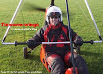
I have been experimenting with ways to navigate using only one leg for my map....and the simplest is to photocopy 1:1 my map and assemble and laminate a slice 17cm (approx 25 st.miles) deep x 60cm in length (allowing for a flight of 75 st. miles E-W or vice versa) and wrap it around my leg (and ends joined with velcro) in a tube which can be rotated around my leg.
I have also made a prototype "window", secured to my flying suited leg top and bottom, which will direct airflow over the map to stop it lifting, but which could also have scale on it, and which could provide, as this trial does, a 1/2 hr or 17mile (at trim speed) view. It is made from A5 laminate sheet and secured with sticky-backed velcro.The window might over-complicate things though.
To keep your place you could even have a magnetic circle on the window-top and a metal disc inside the window, then slide the circle to approx position before doing other things.
This slice allows for a flight from Rougham to Sywell, taking in Sutton Meadows and Sackville.
Note
Incidentally, no map was harmed in the making of this prototype. (well, strictly speaking, a 2006 map of Poland was sacrificed. It was rescued from a Flylight skip after the championships)
Another method would have to be employed if flying a similar distance N-S. I have a few cunning plans in mind, like a variation on this instructable, which I have made, which takes up a space on the leg of roughly A6 *(see note), yet can accommodate 75 miles in any direction. But this can get complicated to use, and will need development ....especially if I am to use it with gloves on). It involves flaps folding left to right or up and down, variously.


 * Note
ref A6. This is the size of A4 folded in half twice; I have also folded an A3 map to do something similar - though in both cases this solution requires more folds than that and includes a cut or two, so don't use originals unless you are a wealthy flier


.JPG)
.JPG)


.JPG)


No comments:
Post a Comment